On this page
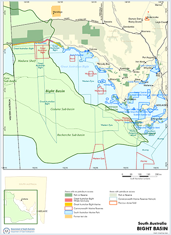
 The Bight Basin is a Late Jurassic to Late Cretaceous basin. The information presented here focuses on the Duntroon Sub-basin.
The basin comprises fluvial to paralic sediments of Late Jurassic to Early Cretaceous age, disconformably overlain by nearshore marine to non-marine Late Cretaceous sediments.
Important Note on the Regulatory Regime for Offshore Waters
Prior to 2012, each State and Territory was responsible for petroleum licensing and regulation in their respective offshore waters. However, following the amendment of the Offshore Petroleum and Greenhouse Gas Storage Act 2006 to implement recommendations from the Productivity Commission, responsibility for the licensing and regulation of petroleum-related activities occurring greater than 3 nautical miles from shore (or, technically, from the territorial sea baseline) passed from the various States and Territories to the Commonwealth Government. The National Offshore Petroleum Titles Administrator (NOPTA) was created to have responsibility for the day-to-day administration of petroleum & greenhouse gas titles in Commonwealth waters, with Geoscience Australia managing the well and seismic database (NOPIMS) for these areas on their behalf.
Summary
| Age | Late Jurassic - Late Cretaceous |
|---|---|
| Area in South Australia | 57 000 km2 (22 010 sq. miles) |
| Depth to target zone | 2000 - 3700m |
| Thickness | 11 km |
| Hydrocarbon shows | Oil shows Greenly 1 (1993) |
| First commercial discovery | None |
| Identified reserves | Nil |
| Undiscovered resources (50%) | Not determined |
| Production | Nil |
| Basin type | Rift |
| Depositional setting | Non-marine-paralic (Early Cretaceous); fluviodeltaic to marine (Late Cretaceoous) |
| Reservoirs | Non-marine to fluviodeltaic sandstone |
| Regional structure | Faulted tilt blocks, rollover anticlines, flower structure |
| Seals | Non-marine shales |
| Source rocks | Non-marine shale, coaly interbeds |
| Number of wells | 6 |
Seismic line km | 26 785 2D |
For more information, contact:
-
Geoscience Australia has the latest information on Australia’s offshore basins:
Bight Basin | Geoscience Australia
Energy Resources Division
DEM.Petroleum@sa.gov.au -
Refer to NOPIMS for up to date offshore well information:
National Offshore Petroleum Information Management System (NOPIMS)


