Steve Hill
Geological Survey of South Australia, Department of the Premier and Cabinet
Download this article as a PDF (4.3 MB); cite as MESA Journal 86, pages 4–13
Introduction
The Geological Survey of South Australia (GSSA) provides innovative and high-quality geoscience for the benefit of South Australians. This is achieved through the creation, collection, management and delivery of data, information and knowledge of South Australia’s geology and associated mineral resources and minerals prospectivity. For 2017 the focus was on maintaining a high-level of delivery for the PACE Copper initiative as well as geoscience-based advice and information for South Australia’s government, community and legislative/regulatory responsibilities associated with geological data and information.
In February 2017 the GSSA commenced operations as part of its new organisational restructure. Final staff positions and operations have been put in place throughout 2017, resulting in an increased capacity and capability in key areas of the GSSA’s roles in government, industry, research and community, and better alignment with state and national strategic initiatives. There was a reduction of full-time equivalent staff towards a savings target of approximately $500,000.
A fundamental feature of the new GSSA structure is the recognition of its overarching roles in both geoscience and in legislated activities around resource planning and regulation (Fig. 1). The restructure has also provided opportunities associated with new staff positions and appointments. A more detailed overview of the restructure is provided in the MESA Journal July 2017 news.

Figure 1 GSSA’s new structure (management level) which became operational in February 2017.
Top 10 highlights
1. New geoscience in a new frontier: PACE Copper western Gawler Craton / Coompana geoscience program
Crystalline basement in western South Australia is completely concealed by sedimentary cover, and until this year only three drillholes had penetrated to the basement in the southwest portion of the state. This region hosts some large and distinctive geophysical features, in particular the large circular magnetic anomaly in the Coompana Province and a host of satellite anomalies. Geological understanding and mineral exploration in this region are hampered by the sedimentary cover.
To understand the geology of the Coompana Province, a $3 million PACE Copper drilling project was undertaken by GSSA in partnership with Geoscience Australia’s Exploring for the Future Initiative in 2017. The aims were to drill into each of the major geophysical domains to characterise the rock types and map the buried Coompana Province.

Figure 2 Coompana core samples are lodged at the South Australia Drill Core Reference Library where further analysis is continuing. (Photo 416262)
Eight holes were drilled by South Australian based company Boart Longyear Australia via an open competitive tender process. Drilling commenced in early April 2017 and was completed in mid-September 2017 using a combination of techniques to obtain basement core samples and with minimal environmental impact. Core samples of between 300 and 100 m of crystalline basement were retrieved for each site, totalling >1,800 m of new core to support further studies (Fig. 2).
The sampled rock types ranged from migmatite gneiss, foliated granites, gabbros to dolerites, along with sheared and altered rocks of as yet unknown age, geochemistry and structural evolution. Downhole gamma and temperature logs were also acquired to constrain the stratigraphy of the overlying sediments and the thermal characteristics of the crust. Eight new reports detailing the field data collected on each hole were released.
Following on from the Coompana magnetic and radiometric survey, magnetic modelling by Clive Foss of CSIRO has continued to refine detail of the depth to magnetic basement and the remnantly magnetised Coompana magnetic anomaly and satellite intrusions. Reports from this work are now available. Pre-drilling geophysical surveys included audio magnetotellurics (AMT) and reflection seismic acquisition by Geoscience Australia over eight of the proposed drill targets to evaluate techniques to estimate the thickness of cover. All provided constraints on different aspects of the cover, with AMT showing basement depth mostly to within about 10% accuracy, and reflection seismic imaging variation and overall thickness of the limestone units. Microgravity surveys over each of the drillsites were used to test for caverns in the limestone and thereby to better position drill collars.
The final large data acquisition in this regional program is the PACE Copper Far West geochemical survey in collaboration with Ryan Noble and team at CSIRO. This program tests whether the interpreted major lithological and chemical variations in buried bedrock can be detected through cover sediments using surface geochemical techniques. Landscape and surface geology mapping was done to provide more detailed context for the surficial (e.g. soil, plant, gas) geochemical program. Preliminary survey results were released in December at the GSSA Discovery Day. The geochemical program used innovative field laboratory sample preparation and analyses to provide indicative results at the time of sampling that allowed infill and follow-up sampling to be done while the field team was onsite.
Useful links
2. Industry collaborative drilling: PACE Copper Discovery Drilling
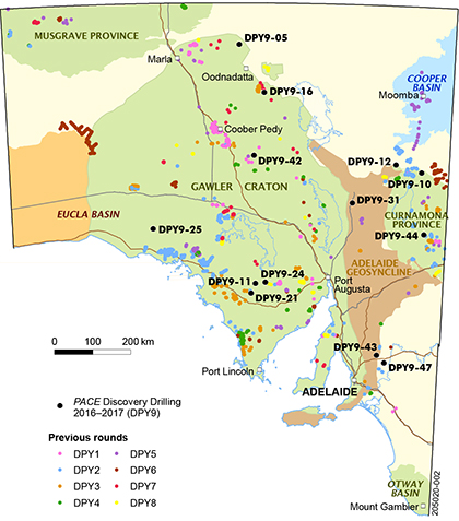
The PACE Copper Discovery Drilling Program uses government funds to leverage an equivalent or greater amount of private investment in mineral exploration, thereby creating a multiplier effect of direct and indirect investment and employment throughout South Australia as well as creating new open file data. This program has been running since 2004 (Fig. 3) and has produced a strong legacy of mineral discoveries, such as Carrapateena, as well as a long-term greater than 20:1 financial return on government investment. It is now in its ninth round of funding, where the PACE Copper 2016–17 investment of $1.3 million in drilling grants has leveraged an additional $2.4 million of company expenditure (185% return on investment) across 13 industry drilling projects and 30,000 m of drilling. Furthermore, this investment has supported the retention and creation of 70 direct jobs in the mineral exploration industry in South Australia and a further 280 indirect jobs, many of which are in regional South Australia.
Industry highlights from this round of drilling have included:
- Investigator Resources identified alteration that is consistent with porphyry copper systems at the Nankivel (Peterlumbo copper–gold) project area.
- Minotaur Exploration identified iron sulfide – copper–gold (ISCG) mineralisation in the eastern Gawler Craton, which provides new regional exploration opportunities.
- Havilah Resources and Red Metal identified rocks consistent with iron oxide – copper–gold (IOCG) and ISCG mineralisation in the Curnamona Province.
Useful links
- Technical reports and data from this drilling can be downloaded from SARIG.
3. Unique partnership across industry: Mineral Systems Drilling Program / Gawler Ranges geoscience program
The Mineral Systems Drilling Program (MSDP) was an approximately $8 million cash and in-kind collaborative drilling program with the Deep Exploration Technologies Cooperative Research Centre (DET CRC), two mineral exploration companies, five supplier companies and three research organisations, and managed by the GSSA. Its objective was to progress the understanding of mineral systems developed during c. 1590 Ma magmatism in the southern Gawler Ranges. It has also been vital for the research and development towards commercialisation of new technologies required for drilling beneath cover. The drill program was completed on 26 April 2016, and in 2017 there has been further data collection and information delivery. One of the major outcomes from the program was evidence for epithermal-style mineralisation within the upper Gawler Range Volcanics following recognition in drill core of epithermal textures within a broad zone of alteration. This model opens up wider areas of the state to new exploration targeting.
All drill core has been characterised through detailed mineralogy (HyLoggerTM and petrology), geochemistry (Lab-At-Rig® and laboratory assays) and petrophysics, which are now available for download through SARIG. In 2017 geochemical data was also collected using the Minalyzer CS, a new semi-portable drill core XRF scanner hosted at the South Australia Drill Core Reference Library. The MSDP holes were used to evaluate this technique due to the extensive chemical data available for comparison.
The MSDP drill core has also been used to determine the age of crystallisation of select igneous units in the region. Further to this, consultant volcanologist Carol Simpson provided detailed interpretation of drill core, which together with GSSA mapping provide much improved understanding of the stratigraphy, depositional environment, tectonic controls, thickness and distribution of the Gawler Range Volcanics. Researchers from the Centre for Ore Deposit and Earth Sciences (CODES) at the University of Tasmania have used detailed mineral chemistry analyses on MSDP drillholes to also provide prospectivity indicators for mineralisation.
There have been three major map releases for the southern Gawler Ranges associated with areas around MSDP drillholes. These provide a regional geological context in which the stratigraphy, alteration and mineralisation intersected in the MSDP drillholes could be interpreted. Maps have associated explanatory notes, field observations, and rock analyses, all of which have been publicly released.
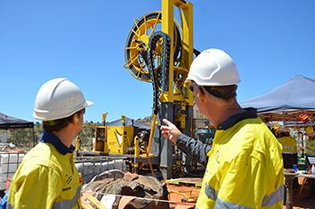
Figure 4 In February and March 2017 the RoXplorer® coiled tubing drilling rig underwent its first field trial, at a MSDP drillsite near Port Augusta. (Photo 415168)
The MSDP facilitated extensive field testing of new DET CRC technology. In 2017 the RoXplorer®, DET CRC’s new coiled tubing drilling rig, had its first field trial at a MSDP drillsite near Port Augusta (Fig. 4). This marked a defining milestone for DET CRC and demonstrated to the wider exploration community that the revolutionary drill rig is a viable method of addressing the aim of cheaper and faster drilling in hard rock environments.
Useful links
- Video series on geological outcomes and technology trials for the MSDP (DET CRC TV)
- MSDP report
- Volcanologist reports (4)
- Geochemistry report
- Map releases (4)
- Outcrop sample pictorial catalogue report
- Discovery Trail: Rocks of the southern margin of the Gawler Ranges (virtual tour in SARIG).
4. Mapping the lithosphere for South Australia’s mineral systems: PACE Copper magnetotellurics
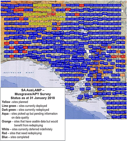
Magnetotelluric (MT) data has become critical for imaging lithospheric architecture. South Australia now hosts the greatest number of MT data stations of any jurisdiction in Australia. PACE Copper funded MT research has now completed 95% data acquisition of the Australian Lithospheric Architecture Magnetotelluric Project (AusLAMP) South Australia program, with about 30 stations remaining in the Anangu Pitjantjatjara Yankunytjatjara Lands scheduled for collection in March 2018 (Fig. 5). New modelling results across the southern two-thirds of the state highlight correlations between IOCG and gold prospective areas and zones of enhanced conductivity in the lower crust.
The next phase for these surveys will focus on closer spaced broadband MT studies, which have already produced new insightful results and zones for exploration targeting across the Curnamona Province in 2017. Data collection across the Olympic Domain commenced at the end of 2017 and provide insights into the geometry of ancient pathways into the upper crust beneath the IOCG belt in the Stuart Shelf. The dataset will be complemented by an airborne electromagnetic (EM) survey across the same area to establish a seamless EM dataset from the lithospheric mantle to the sediment cover.
A further outcome of the government’s MT program has been the increased planning and application of more detailed scale MT surveys by the mineral exploration industry, such as in the Burra region, the eastern Gawler Craton and parts of the Curnamona Province.
Useful links
5. A foundation for a new generation of Gawler Craton discoveries: PACE Copper Gawler Craton Airborne Survey
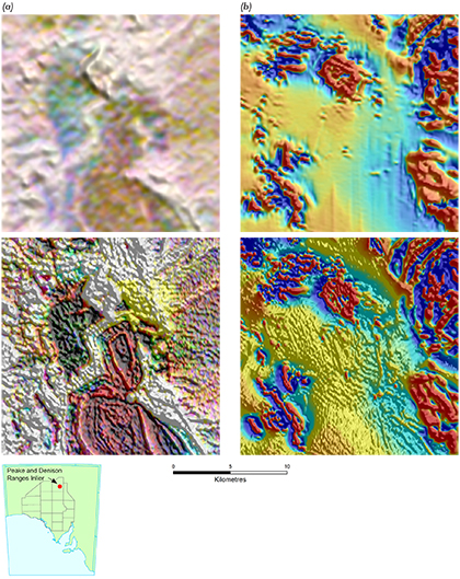
Figure 6 Comparison of radiometric and magnetic images before (top) and after (bottom) the Gawler Craton Airborne Survey, Block 2B, Peake and Denison Ranges Inlier. (a) Ternary radiometrics. (b) Total magnetic intensity, reduced to pole, first vertical derivative.
Airborne magnetic data is a foundation dataset for mineral exploration that enables interpretation of the first order structure and rock types of the area. As airborne data is seamless, it is especially important in terranes with large amounts of sedimentary cover, such as the Gawler Craton, where outcrop is discontinuous, or absent. Each of the incremental advances in resolution of large government airborne magnetic surveys since the 1970s has provided a baseline from which major mineral deposits have been discovered in South Australia.
In 2017 GSSA initiated the PACE Copper Gawler Craton Airborne Survey to collect magnetic, radiometric and altimetry data across an unprecedented area of South Australia. The survey will collect 1,800,000 line kilometres of new magnetic, radiometric and digital elevation geophysical data over an area of approximately 324,000 km2. This new data will far surpass the current ‘patchwork’ of surveys and provide a single, uniform dataset. Data is now available via SARIG from the first tranche of acquisition and the acquisition of the second tranche is well underway. Sequential data releases and derivative products are planned throughout 2018.
The survey, delivered in partnership with Geoscience Australia, is Australia’s largest airborne geophysical program and is setting new benchmarks in data capture and delivery formats, such as doubling sample density on flight lines, using laser altimeter data to derive digital elevation models and establishing a new test line to enable quantitative collaborations and comparisons of acquired data. Improvements in the radiometric data will also improve the ability to characterise the cover, not just for the minerals industry, but also for a wide range of landscape mapping and land management applications. For instance, improved resolution and quality of radiometric data flanking the Peake and Denison Ranges shows source areas of elevated uranium that are dispersing and reconcentrating in the cover to the east (Fig. 6).
The data provides improved precision for mapping mineral system targets under cover, such as targeting IOCG (e.g. Olympic Dam, Carrapateena, Prominent Hill) and ISCG (e.g. recent Minotaur – OZ Minerals exploration at Mount Woods) systems. There has also been strong company interest in infilling this data (from the survey 200 m spaced lines being closed down to 100 m spacing) to even better define new drill targets. CSIRO analysis of the data is now underway (the first results were released in December at the GSSA Discovery Day) creating increased confidence in depth of cover that is critical for designing drilling programs and defining economic search space. Further interpretations and mineral system targeting is planned for this data into the future.
Useful links
6. New GSSA product releases: maps, publications, data and conferences
One of the key missions for the GSSA is to deliver new geoscience knowledge about South Australia to the world. During 2017, 18 external, peer-reviewed papers were published in international geoscience journals on subjects ranging from lithospheric architecture of entire regions via deep source geophysics, through to isotope geology and geochronology and geochemistry of magmatic rocks and the geochemistry of cover sediments. These papers deliver the highest quality geoscience to an international audience.
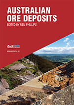
A major publication highlight was the Australasian Institute of Mining and Metallurgy monograph, Australian ore deposits. Seven chapters were authored by GSSA geoscientists covering the range of ore deposits and geological terranes of South Australia, in what will be a landmark volume for Australia’s mineral resources industry. A further important overview of graphite markets, together with a summary of South Australian graphite resources on the Eyre Peninsula, was published by John Keeling in the MESA Journal. The review reflects a growing demand for graphite for battery anodes, progress with graphite mining proposals at Kookaburra Gully and Campoona, and recent exploration success with discovery, by Renascor, of large graphite resources at Siviour, near Arno Bay.
Other outputs included:
- 22 geoscientific report books on topics ranging from microgravity techniques to field mapping to geochronology.
- 17 MESA Journal articles covering mineral commodities such as graphite through to summaries of new work on the lithospheric architecture of South Australia.
- Four exploration data packages including the first tranches of the Gawler Craton Airborne Survey released via SARIG.
- Two digital maps released from Peltabinna mapping program, associated with the MSDP.
2017 also marked a huge increase in data production and delivery in SA Geodata, South Australia's chief repository for most forms of geoscientific data. Drillhole data grew by 4%, rock samples by 20% and analytical data by 52% (Fig. 7).
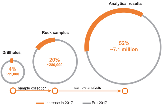
Figure 7 SA Geodata, South Australia's chief repository for most forms of geoscientific data, grew significantly in 2017 particularly for digital analytical data.
In 2017 GSSA geoscientists also shone light onto South Australia from afar.
- Steve Hill and Stephan Thiel were invited speakers at a regional terrane-scale assessment session during the PDAC conference in Toronto, Canada, in March 2017.
- In August Anthony Reid presented on South Australia’s mineral endowment to the Society for Geology Applied to Mineral Deposits, Quebec City, Canada.
- In September Stephan Thiel was an invited speaker at the International Association of Geomagnetism and Aeronomy convention, Cape Town, South Africa. As part of the convention, Stephan ran a short course on MT applied to mineral exploration attended by geophysicists from across the world.
- Baohong Hou presented an invited keynote address at the Society of Economic Geologists conference in Beijing, China, in September, which was also attended by Marc Twining.
- Steve Hill presented on the future of Geological Survey drilling programs at Exploration’17 in Toronto, Canada, in October, as well as presenting on the MSDP and future drilling programs as part of a conference workshop.
- Kate Robertson and Stephan Thiel were invited speakers at the 2017 American Geophysical Union conference in New Orleans, USA, in December presenting on the large-scale AusLAMP MT program across South Australia. It is the largest annual geophysics meeting in the world with an average of 25,000 attendees.
Useful links
7. Major national geoscience and mineral exploration strategic contributions
As part of a national and international mineral exploration community, and more specifically as the GSSA’s role as a part of Australia’s precompetitive geoscience programs, the GSSA has been active in the development of major national strategic plans and documents in 2017.
GSSA has been a sponsor of the AMIRA UNCOVER Roadmaps Stage 1 and Stage 2 and eight of its staff participated in planning and sponsors workshops for these. Steve Hill has also been a member of the UNCOVER Geoscience Committee. This roadmap has brought together representatives from industry, government and research to provide direction for Australia to be a global leader in exploration beneath post-mineral cover rocks. Exploration management consultant Robbie Rowe provided leadership on the preparation of the roadmaps, and as part of this led two excellent workshops for GSSA staff to foster engagement and awareness.
The GSSA, largely through its representation on the Geoscience Working Group of the COAG Energy Council, has been a contributor and supporter of the development of a new National Mineral Exploration Strategy 2017–2022. This strategy helps to articulate the program and drive ongoing investment in mineral exploration, generate new exploration opportunities, stimulate major new discoveries, and ensure the continuity and longevity of Australia’s mineral resources industry for the benefit of all Australians.
The GSSA has also played an active role in the development of a bid for $50 million of Commonwealth government funding as part of the MinEx CRC bid. This bid brings together industry, researchers and government to revolutionise 3D drilling in Australia, particularly using the new coiled tubing drill rig technology as part of a National Drilling Initiative that will support the development of a new generation of geological maps from drilling samples and data within and through the cover across the continent. The successful Stage 1 bid was submitted in June 2017, with Stage 2 bids submitted in December, towards a final selection of successful bids made in early 2018.
Useful links
8. South Australia Drill Core Reference Library
The state-of-the-art South Australia Drill Core Reference Library in Tonsley hosts an innovative mineral exploration workflow for working with drill core and associated data in South Australia. From the moment drill core is received, this workflow extends from the physical storage and viewing of core through to real-time and non-destructive analysis and the presentation of associated data and information in meeting and conference facilities and an immersive 3D theatre. Since its completion in 2016 it has won numerous architectural awards and is now placed as one of the top six finalists in the WAN Metal in Architecture Award 2017 (to be announced February 2018) (Fig. 8).
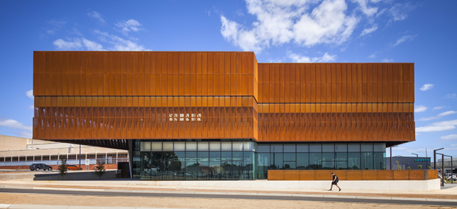
Figure 8 The state-of-the-art South Australia Drill Core Reference Library at Tonsley. (Photo 416261)
A major highlight for 2017 has been that the facility is beginning to realise its potential for the incubation of new technologies associated with the drilling workflow, particularly in the emerging field of real-time and non-destructive analysis of drill core. Technology partners at the Core Library have included Olympus, Reflex, Minalyze, Gold Sniffer and Corescan. The library also hosts a collection of over 80,000 samples as part of the world’s largest mineral deposit database, Data Metallogenica, in partnership with AMIRA International.
2017 has been a very busy year at the Core Library, including:
- 155 inspections
- 805 drill cores viewed
- 23,349 trays viewed
- 3,092 samples taken for analysis
- 904 core library inspection visitors
- 77 core library events, tours, visiting delegations, industry workshops
- 2,504 event guests.
Useful links
9. Next generation of geoscientists for tomorrow’s discoveries: education and training
A major activity of the GSSA is its promotion and fostering of the development of geoscience in South Australia through its partnerships in education and training. This is achieved in partnership with universities conducting research and teaching in earth sciences. A major activity in 2017 was GSSA’s participation in the National Exploration Undercover School (NExUS), which was initiated in 2016. This is coordinated through the University of Adelaide and is run in South Australia with support and sponsorship from the Minerals Council of Australia and GSSA. Over 33 participants from around Australia registered for 2017, with five teaching sessions contributed by GSSA staff. The South Australia Drill Core Reference Library hosted week 1 (Fig. 9), with weeks 2 and 3 conducted in the Adelaide Hills and Yorke Peninsula, respectively. The GSSA also provides staff support for field course teaching at the University of Adelaide for 3rd year mapping at Arkaroola and staff and financial support for the 4th year field course in New Zealand. The GSSA supported the Geological Society of Australia’s Earth Sciences Student Symposium in South Australia in November. GSSA staff also participated in a student mentoring program run by the Geological Society of Australia SA Division.
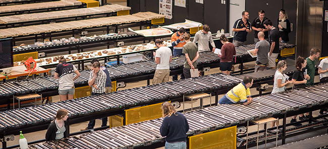
Figure 9 Week 1 of the 2017 National Exploration Undercover School was held at the Core Library. Drill core logging exercises. (Photo 416264)
Over the course of the year, GSSA geoscientists co-supervised a range of research students including three PhD students and several honours projects via the $225,000 research project supported by GSSA and the Australian Research Council and based at the universities of South Australia, Adelaide and Monash. GSSA also sponsors and co-supervises two PhD students from Saskatchewan universities at the University of Adelaide for PhD studies on the structural geology of uranium deposits. Of the DET CRC cohort of postgraduate students, GSSA staff have so far co-supervised five PhD completions and four ongoing PhD students.
The GSSA sponsored a major public geoscience competition, the Frank Arnott Award, where teams of geoscientists from around the world submitted entries featuring data integration and 3D representation from six selected case study datasets. The GSSA provided a dataset from the Gawler Craton that was used by several of the finalists in the competition, including the ‘Team on the Rock’ from the University of Adelaide which won the apprentice category.
Useful links
10. International and national collaborations and partnerships
Our collaborations and partnerships continue to be an important part of the broad impact of the GSSA. In 2017 GSSA partnered with the Geological Survey of New South Wales and the Geological Society of Australia to bring together mineral explorers and geoscience researchers for a two-day UNCOVER Curnamona conference and field trip at Broken Hill. Attended by over 100 people, the conference is an enabler for increased cross-border geoscience exchange between the two jurisdictions and highlighted the geoscience and exploration being undertaken in the Curnamona Province.
GSSA also continues collaboration with other Australian geoscience organisations including via presentations by Anthony Reid at the biennial Science in the Surveys event hosted in Melbourne by the Geological Survey of Victoria and Australia Minerals, and at the Northern Territory Geological Survey annual meeting in Darwin. Geoscience Australia is our largest collaborative partner, including a number of projects previously mentioned, as well as U–Pb geochronology via a National Collaborative Framework Agreement. Several projects also partner with CSIRO, including processing and advice with airborne electromagnetic surveys, airborne magnetic surveys, and far western South Australia geochemical surveys.
New research into the diversity of mineral deposits associated with the Gawler Range Volcanics began in 2017 with a $225,000 research project supported by GSSA and the Australian Research Council, and based at the universities of South Australia, Adelaide and Monash.
International collaboration continues to bring world-class geoscience knowledge to South Australia. Visits by geoscientists from the Nanjing Branch of the China Geological Survey resulted in new biogeochemical surveys and fieldwork. Building on an earlier work program at the Paris silver deposit, this year the collaborative research focused on biogeochemical sampling in the Mount Painter region. A joint paper with memorandum of understanding partner, China National Nuclear Corporation (CNNC), was published in Ore Geology Reviews on sandstone-hosted uranium deposits and exploration approaches in Australia and China. Baohong Hou, Marc Twining, and Steve Hill were hosted by CNNC on a visit to sandstone-hosted uranium deposits in the far west of China during September as part of their attendance at China Mining (Fig. 10). Further collaboration and technical exchange with Zhejiang University of Technology on industrial minerals research, led by John Keeling, resulted in publication of research on a new approach to synthesise hydrotalcite from dolomite to produce an effective adsorbent for removal of organic contaminants from water.
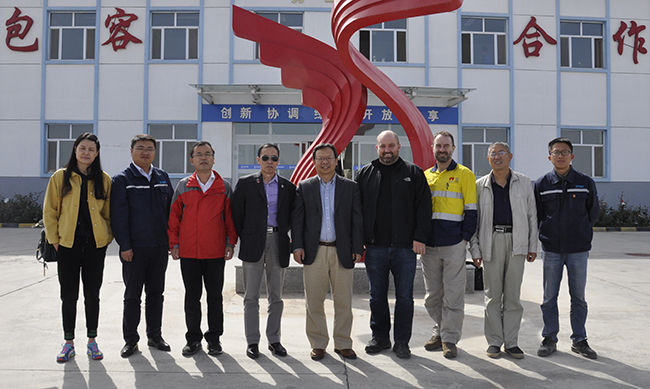
Figure 10 L–R: Xuelian Chen1, Qinglin Zhang1, Jianguo He2, Baohong Hou3, Prof. Ziying Li2, Steve Hill3, Marc Twining3, Yiqun Xu1 and Hongbin Ji1 outside CNNC Xinjiang Tianshan Uranium Co. Ltd office, China. (1 CNNC Xinjiang Tianshan Uranium Co. Ltd; 2 Beijing Research Institute of Uranium Geology, CNNC; 3. Geological Survey of South Australia) (Courtesy of CNNC Xinjiang Tianshan Uranium Co. Ltd; photo 415983)
As part of his Canadian visit in August, Anthony Reid spent time at the Saskatchewan Geological Survey (SGS) presenting geochronology results collected in collaboration with SGS from the Athabasca Basin, Saskatchewan, one of the world’s great uranium provinces. The GSSA and SGS also co-support two PhD students researching the structural geology of uranium deposits at the University of Adelaide. These studies include fieldwork in both South Australia and the Athabasca Basin.


