Targeting the central–western Gawler Craton.
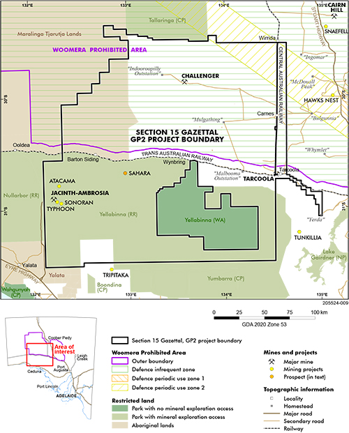
The area chosen for the first round of data acquisition phase for the Gawler Phase 2 (GP2): next generation mineral system mapping project is prospective for gold and intrusion-related magmatic Ni–Cu–PGE mineral systems. Selection was based on the existence of major data gaps and the area’s predicted prospectivity in many of last year’s submissions to the ExploreSA: The Gawler Challenge. The Geological Survey of South Australia (GSSA) has taken out a Mining Act 1971 Section 15 gazettal over the area to ensure that no one company will receive a precompetitive advantage (Fig 1). It includes the Challenger gold deposit, Tarcoola goldfields and recently discovered Sahara Ni–Cu prospect.
Figure 1 Central–western Gawler Craton showing the Section 15 gazettal area selected for the first round of GP2 data acquisition.
Geological and geophysical acquisition programs are underway and will operate until early-mid 2022. These include geochronological, geochemical and petrophysical analyses of existing publicly available drill core across the region, and magnetotelluric and gravity data acquisition and modelling. There will be more targeted data acquisition throughout the lifetime of GP2 based on the outcome of the regional acquisitions. The GSSA’s Megan Williams is enabling the ambitious program of geochronology and isotope geochemistry.
GP2 has a tripartite structure – acquisition, data science and insight. The data science component has commenced too. A data audit of legacy drillhole data not included in the Gawler Challenge identified 6,234 drillholes, 300 drillhole lithology logs and almost 250,000 sample analysis results. These will be added to our geoscience databases over the next 6 months and will be available via the South Australian Resources Information Gateway, SARIG.
Also within the data science sphere, the GSSA is investigating how to better serve data to the data science and exploration communities. New cloud-based web services built using internationally accepted standards will be trialled, and methods to improve the information around the services are being investigated to allow users to better understand the data as well as its quality. These improvements will ensure users can have greater confidence in the data itself and are empowered with the knowledge to make best use of the data.
ExploreSA data audit
The main outcomes of the top 25 entries of ExploreSA: The Gawler Challenge have been summarised in separate reports by Consilium Technology and Solve Geosolutions. The findings are being used to inform the delivery of precompetitive geoscience data for the GP2 project. The summaries, prepared by Consilium Technology and Solve Geosolutions, praise the quality and breadth of the submissions.
GSSA’s Peter Buxton and Stephan Thiel met with consultants from both companies – Ben Schultz, Mark McDonnell, Luisa Herrmann and Tom Carmichael – for a video interview of the main findings and the outcomes. The discussion touches on key learnings for the application of machine learning for the mineral exploration sector, common issues met in the submissions and how the entrants tackled the spatial aspect of multi-scale point data. It became clear that the broad questions posed to the entrants led to a very diverse set of submissions, which often did not use the same datasets or approaches and made a direct comparison difficult. Future data science challenges will pose more focused questions – e.g. determination of depth to basement using various datasets, or applications to specific commodity prospectivity.
Keep up to date with the GP2 project
– Stephan Thiel and Peter Buxton, October 2021


