
Summary
| PLAY | Upper Sawpit Shale |
| BASIN | Otway |
| LOCATION | Onshore Otway Basin, South Australia |
| AGE | Early Cretaceous |
| RESERVOIR | Upper Sawpit Shale |
| SEAL |
Pretty Hill Sandstone shales & siltstones Northeast: Eumeralla Formation shales & siltstones |
| SOURCE ROCK/S | Upper Sawpit Shale, Lower Sawpit Shale, Casterton Formation |
| HYDROCARBON PHASE | Gas & Oil |
| PRODUCTION | 12,784 barrels of oil and 0.16Bcf of gas in total from Upper Sawpit Shale between August 2007 and October 2011 |
| HYDROCARBON FLOW RATES | Highest average monthly production rates were 793,00m3pd/ 2.8MMcfd and 226bopd (both from Jacaranda Ridge 2) |
| POTENTIAL RESOURCES | MER estimate August 2002 (Morton and Boult, 2002): 50% probability of 680PJ (623bcfg) in Crayfish Group |
Location maps
Geological Setting maps

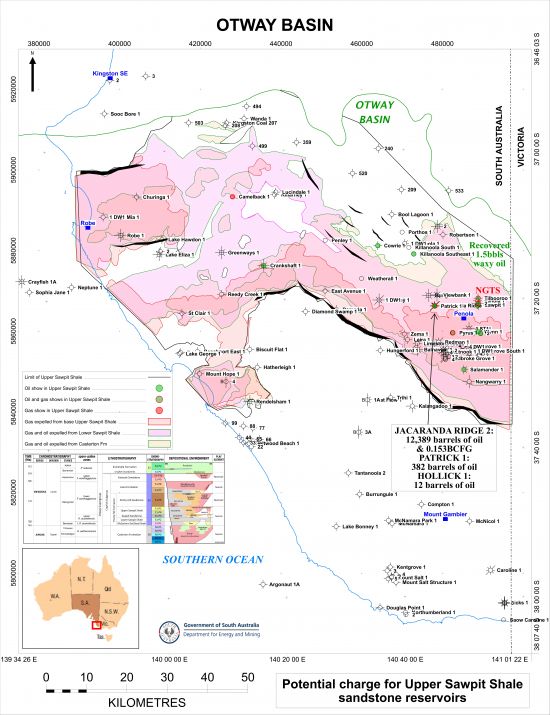
The Upper Sawpit Shale play exists in the onshore Otway Basin in South Australia.
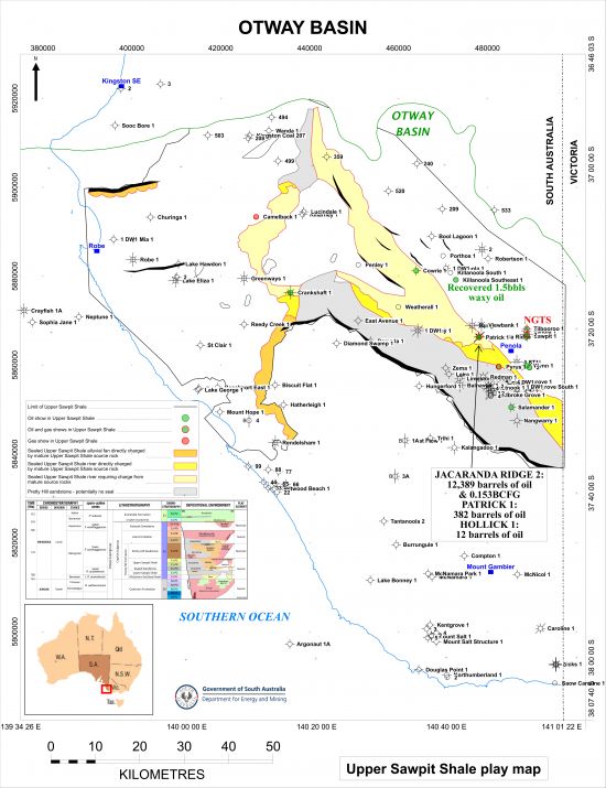
Download play extent map of the Upper Sawpit Shale (JPG 5.5 MB)
Sandstones within the Upper Sawpit Shale show good reservoir quality, although maybe not quite as good as for the Pretty Hill Sandstone. Average monthly production rates have been up to 793,00m3pd/2.8MMcfd of gas and 226bopd, both from Jacaranda Ridge 2 (PEPS South Australia).
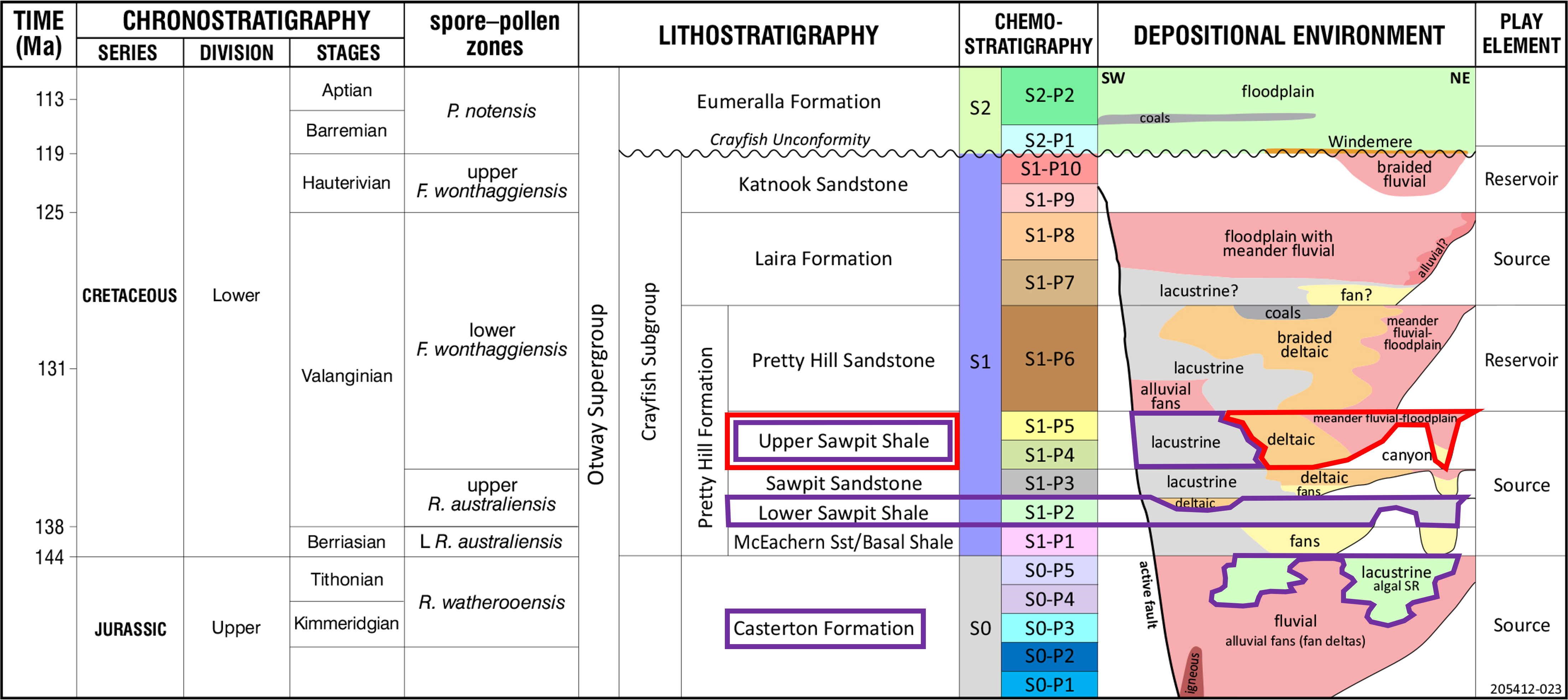
Morton et al (2002) reported that pore volume reduction with depth is not considered a major risk for the Pretty Hill Formation* due to the suppression of quartz overgrowth formation, and that porosity may be found even in the deepest parts of the Penola Trough. This may well be the case for reservoirs within the Upper Sawpit Shale.
* NB: This definition of the Pretty Hill Formation is from Morton et al (2002), which consisted of the Pretty Hill Sandstone, the Upper Sawpit Shale, the Sawpit Sandstone and the Lower Sawpit Shale which have been used in the 2023 DEM Petroleum Systems Study. For the study and this subsequent play analysis the reservoir interval at the top of the Pretty Hill Formation is called the Pretty Hill Sandstone Member.
In total, 12,784 barrels of oil and 0.16Bcf of gas were produced from the Upper Sawpit Shale in the onshore Otway Basin between August 2007 and October 2011. The following wells have produced oil and gas from the Pretty Hill (data from PEPS South Australia):

In addition, 1.5 barrels of waxy oil were recovered from the Upper Sawpit Shale on DST in Killanoola Southeast 1.
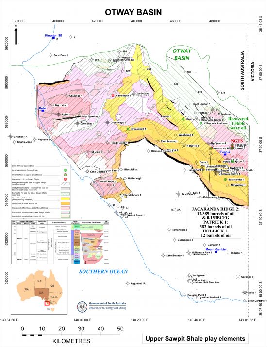
A review of the stratigraphy in the basin, description of core data and seismic mapping conducted by DEM in 2022/23 reviewed the gross depositional environments of the Upper Sawpit Shale, identifying a major sediment input canyon system in the north feeding major braided and anastomosing river systems surrounded by extensive floodplains, which may contain smaller river systems and/or crevasse splays. In addition, there may have been alluvial fans formed in the hanging walls of some of the major faults.

Gross depositional environments of the Upper Sawpit Shale in the onshore Otway Basin (JPG 5.7 MB)
The seal to the Upper Sawpit Shale sandstone reservoirs over most of the onshore Otway Basin in South Australia is the floodplain facies of the Pretty Hill Sandstone immediately above, with floodplain facies of the Upper Sawpit Shale providing lateral seal and potentially acting as a top seal as well. Over the north-east and parts of the north where the Pretty Hill Sandstone is absent seal is provided by shales of the Eumeralla Formation.
However, where the Pretty Hill Sandstone river systems and alluvial fans are present there may not be a competent seal for Upper Sawpit Shale sandstone reservoirs as the former may have acted as migration paths for hydrocarbons into reservoirs higher in the section.
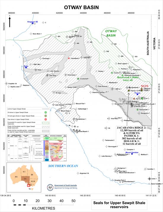
Extent of seals for Upper Sawpit Shale reservoirs (JPG 6.5 MB)
There are several intervals in the onshore Otway Basin that contain suitable material to have acted as potential source rocks for charge of hydrocarbons into the Pretty Hill Sandstone reservoir:
- the Early Cretaceous Eumeralla Formation
- the Early Cretaceous Laira Formation of the Crayfish Subgroup
- the Early Cretaceous Upper Sawpit Shale of the Crayfish Subgroup
- the Early Cretaceous Lower Sawpit Shale of the Crayfish Subgroup, and
- the Late Jurassic Casterton Formation.
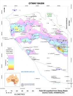
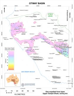
Basin modelling in the onshore Otway Basin conducted by DEM (2023 DEM Petroleum Systems Study) suggests that both gas and oil have been expelled from major source rocks in the onshore Otway Basin.
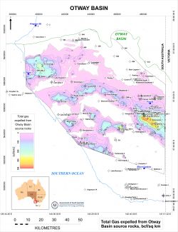
Download total gas expelled from Otway Basin source rocks map (JPG 5.9 MB)
Download total oil expelled from Otway Basin source rocks map (JPG 5.5 MB)
1. Eumeralla Formation
Basin modelling in the onshore Otway Basin suggests that the Eumeralla Formation has not been mature for generation and expulsion of hydrocarbons in the onshore Otway Basin.
2. Laira Formation
The Laira Formation has been recognised as a potential source interval for hydrocarbons in the onshore Otway Basin since the 1990s, containing algal-rich zones with high TOC deposited in lacustrine conditions (Hill and Boult, 2002). Hydrocarbon Index (HI) values indicate that the Laira Formation is predominantly Type IV grading to at best Type III kerogen so is mainly gas-prone.
Basin modelling in the onshore Otway Basin conducted by DEM in 2023 suggests that the Laira Formation has only ever been mature for generation and expulsion of gas in the deepest parts of the Penola Trough and Tantanoola Trough, where it is over 1000m thick; maturity of this source rock interval has not previously been identified in the Tantanoola Trough. However, the Laira Formation sits stratigraphically above the Upper Sawpit Shale, and so it is unlikely that the latter has been charged by gas generated from the Laira Formation.
See the Laira Formation play for a map of the modelled gas expelled from the base of the Laira Formation.
3. Upper Sawpit Shale
The Upper Sawpit Shale is the interval referred to as the “Intra-Pretty Hill Formation (Sawpit) shales” by Hill and Boult (2002), with the source rock interval representing lacustrine deposits over 200m in thickness in the Penola Trough and over 100m in the Robe Trough. Source richness of this interval is fairly uniform and constitutes a good source rock (mean TOC = 1.22%). Source quality is marginal to moderate, with little variation in kerogen type and source potential between the unnamed basal shale and intra-Pretty Hill shale.
The DEM basin modelling indicates that significant amounts of gas may have been generated from the Upper Sawpit Shale in the deepest portions of the Penola Trough close to the border between South Australia and Victoria, although the interval appears to have been mature for gas generation in the rest of the Penola Trough and also in the St Clair Trough, the Rivoli Trough and the Robe Trough.

Modelled gas expelled from the top of the Upper Sawpit Shale in the onshore Otway Basin (JPG 4.9 MB)
Modelled gas expelled from the base of the Upper Sawpit Shale in the onshore Otway Basin (JPG 5.2 MB)
4. Lower Sawpit Shale
The Lower Sawpit Shale interval is of significant thickness in the onshore Otway Basin, being over 3000m thick in the deepest parts of the Penola Trough, and over 1500m thick in the Robe and St Clair Troughs, according to seismic mapping. It consists of two separate intervals deposited in deep lacustrine deposits, some of it interpreted to have been deposited in algal lakes. The basal shale interval is equivalent to the McEachern Sandstone turbidites, and is referred to by Hill and Boult (2002) as the “unnamed basal shale”, the major source rock of the Pretty Hill Formation.
The basin modelling conducted by DEM indicates that the most mature area for generation of hydrocarbons from the Lower Sawpit Shale is the deepest portions of the Penola Trough, with significant amounts of both gas and oil generated. The interval also appears to have been mature for gas generation in most of the rest of where the interval occurs, with potentially large amounts of gas and oil having been generated in the deeper areas of the Robe Trough, the St Clair Trough and the Rivoli Trough.
See the Lower Sawpit Shale play for a map of the modelled gas expelled from the Lower Sawpit Shale.
5. Casterton Formation
The Casterton Formation represents the richest source rock of the Otway Supergroup, although it has only been sparsely intersected. Seismic mapping suggests that it may be over 1000m in places. It comprises pre-rift to early syn-rift interbedded shales, siltstones and sandstones and volcanic lithologies, such of which were reworked from the Basement, deposited under lacustrine conditions, very deep in some places. The richest source rocks contain algal material.
The results of the DEM basin modelling show that the Casterton Formation is mature for generation of gas and oil over just about the whole of the areas where it is present, the exception being in the very north of the Otway Basin.
See the Casterton Formation play for a map of the modelled gas expelled from the Casterton Formation.
Charge for the Upper Sawpit Shale
Gas and oil generated and expelled from Upper Sawpit Shale source rocks are likely to have been the main charge for sandstone reservoirs within the interval given their juxtaposition. However, gas and/or oil expelled from the older Lower Sawpit Shale and the Casterton Formation below may been able to charge Upper Sawpit Shale reservoirs given suitable stratigraphic migration paths or via faulting as well. It is unlikely that the Upper Sawpit Shale has been charged by gas generated from the Laira Formation, as this sits stratigraphically above the reservoir section.
Extents of modelled gas and oil expelled from source rocks in the Upper Sawpit Shale, the Lower Sawpit Shale and the Casterton Formation that may have charged Upper Sawpit Shale reservoirs:
Download potential charge for Upper Sawpit Shale map (JPG 6 MB)
Data from PEPS South Australia:
| Proven production from the Upper Sawpit Shale: | 3 fields in South Australia have produced oil and gas from the Upper Sawpit Shale |
| Number of producing wells at 31 March 2024: |
None 3 wells in South Australia have produced oil and gas from the Upper Sawpit Shale |
| Total production at 31 March 2024: | 12,784 barrels of oil and 0.16BCF of gas from Upper Sawpit Shale between August 2007 and October 2011 |
| | |
| Hydrocarbon flow rates: | Highest average monthly production rates were 793,00m3pd/ 2.8MMcfd and 226bopd (both from Jacaranda Ridge 2) |
Undiscovered recoverable gas resources for the Crayfish Group, including the Upper Sawpit Shale, in the onshore Otway Basin have been estimated as follows (PIRSA estimate August 2002, Morton and Boult, 2002).
| UNDISCOVERED POTENTIAL PJ (~bcf) | ||||||
|---|---|---|---|---|---|---|
| PLAY | Probability that the ultimate potential will exceed the stated value | |||||
| 90% | 50% | 10% | ||||
| Crayfish | 120 | (110) | 680 | (623) | 2330 | (2135) |
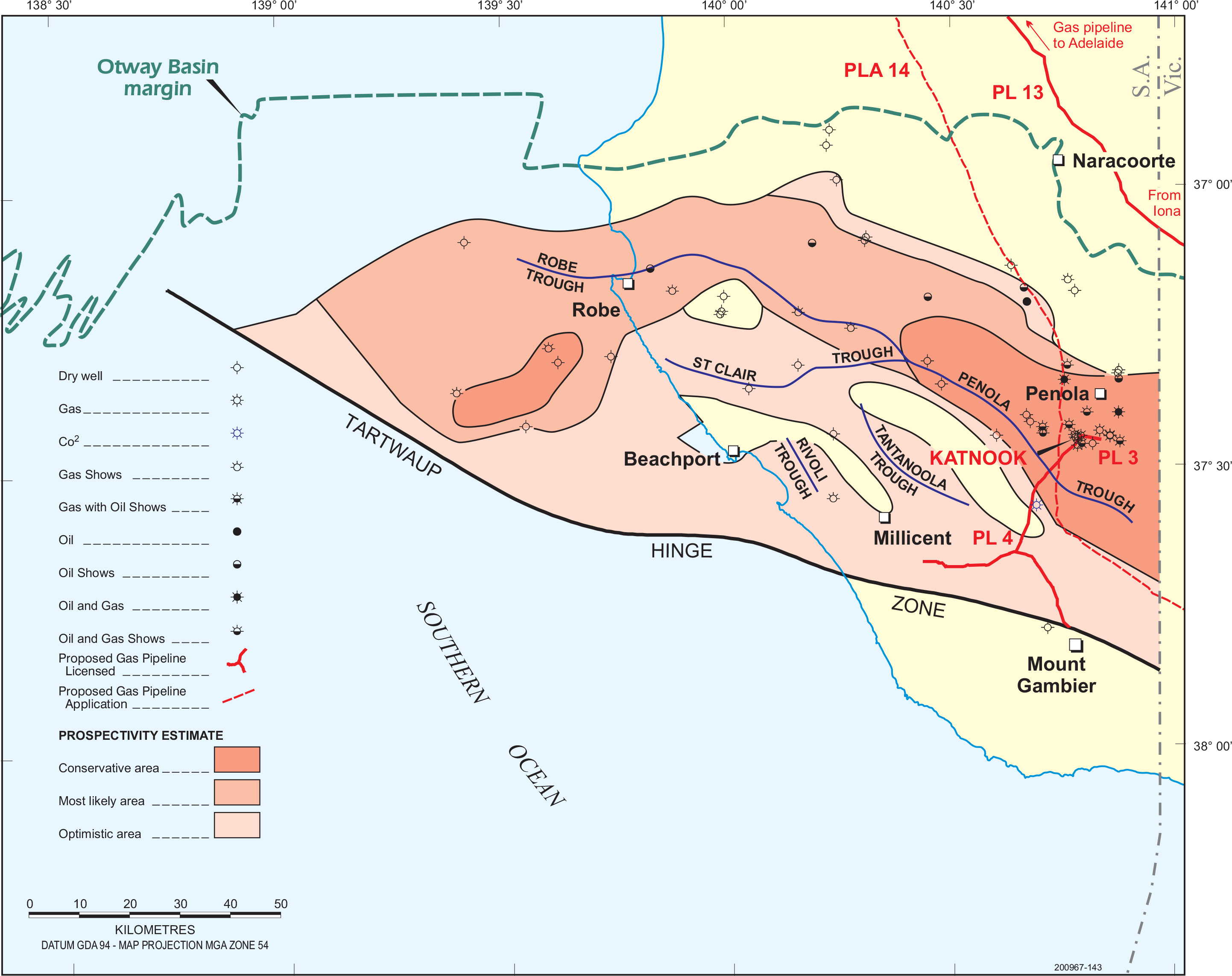
Download Crayfish Group prospectivity map (JPG 1.2 MB). Only wells penetrating Crayfish Group are shown.
Hill, A and Boult, PJ, 2002. Source rock distribution. Chapter 8, Boult, PJ and Hibburt, JE, eds: The Petroleum Geology of South Australia. Volume 1, Second Edition: Otway Basin, South Australia. Department of Primary Industries and Resources. Petroleum Geology of South Australia Series.
Morton, JGG and Boult, PJ, 2002. Undiscovered petroleum resources. Chapter 13, Boult, PJ and Hibburt, JE, eds: The Petroleum Geology of South Australia. Volume 1, Second Edition: Otway Basin, South Australia. Department of Primary Industries and Resources. Petroleum Geology of South Australia Series.
Morton, JGG, Sansome, A and Boult, PJ, 2002. Reservoirs and seals. Chapter 10, Boult, PJ and Hibburt, JE, eds: The Petroleum Geology of South Australia. Volume 1, Second Edition: Otway Basin, South Australia. Department of Primary Industries and Resources. Petroleum Geology of South Australia Series.